 |
If you are interested in exploring how GIS, AI, ML and DL can help support you and your efforts, reach out to Geospatial Discipline Manager Austin Willis, CSM, GISP, at jwillis@hanson-inc.com. |
In today’s connected and data-rich environment, the integration of artificial intelligence (AI) with geographic information systems (GIS) is transforming how projects in a variety of fields are planned, designed and managed. By applying advanced tools such as machine learning (ML) and deep learning (DL), it is easier than ever to better predict project challenges, enhance planning understanding and streamline workflow processes — leading to smarter, more efficient outcomes.
What is GIS?
GIS allows for the integration of spatial technologies, which in turn allows for the collection, management and analysis of data — bringing data to life. Often, GIS is perceived as limited to specific types of data, but that’s not the case. Through GIS, all data types are integrated, which builds a broader understanding of the project environment. It allows us to visualize data through spatial models and, by conveying a comprehensive story, helps decision-makers see patterns, relationships and trends while gaining valuable insights.
As the volume and complexity of data grow, traditional GIS tools can’t keep up. While we face big data challenges, AI, ML and DL are great tools to help solve these challenges.
AI + GIS: smarter spatial decisions
AI refers to the broader concept of machines or systems performing tasks that typically require human interactions or intelligence. In GIS, AI enables systems to:
- automate map generation and visualization
- detect anomalies in spatial data
- recommend optimal routes or location planning
- enhance decision-making with predictive analytics
For example, AI can help emergency responders identify the fastest evacuation routes during a natural disaster by using real-time traffic and weather data.
ML + GIS: learning from location data
Machine learning is a logical subset of AI that allows for system development by introducing data to improve outcomes without specific programming. This is, in essence, when AI starts to evolve from a simple model to a smarter system based on historical input.
In GIS, ML is used to:
- classify land cover from aerial and satellite imagery
- predict urban growth patterns and implications
- detect changes in environmental conditions
- cluster similar geographic features for analysis
For example, ML algorithms can analyze historical flood data and topography to predict flood-prone areas, helping cities plan better drainage systems while understanding the implications on their communities.
DL + GIS: seeing the world in layers
Deep learning is a specialized form of ML that uses neural networks to model complex patterns, especially in image recognition. In GIS, DL is revolutionizing:
- feature extraction from high-resolution imagery
- object detection (e.g., identifying buildings, roads or vehicles)
- real-time video analysis from drones or surveillance
- semantic segmentation of landscapes to support classification
For example, with DL, a model can be trained to automatically identify pavement cracks and assign pavement condition index ratings from aerial images, saving time and enabling faster maintenance. Read more about our geospatial services under “What We Do.”
Real-world applications
The aviation industry depends on precision, safety and efficiency. Integrating AI with GIS can enhance every aspect of operations, from ground logistics to airspace management. AI-powered analytics applied to spatial data can help airports make the most of runway usage, aircraft parking and taxiing routes while predicting maintenance needs based on environmental and operational conditions. GIS platforms visualize these insights in real time, improving coordination and operational decision-making. This integration results in more resilient airport infrastructure and smoother, safer aviation operations.
Public safety is paramount, especially during emergencies and natural disasters. By integrating AI with GIS, federal agencies can enable faster, more informed disaster response. This technology improves coordination across response teams and enhances the ability to predict and model high-risk areas and potential impacts. AI-GIS offers a proactive approach to understanding future conditions, supporting targeted interventions that help restore communities more quickly.
Industry-related operations depend on seamless coordination, whether concerning assets, logistical planning or environmental factors. AI-GIS integration empowers manufacturers and industrial facilities to monitor systems, model workflows and effectively manage spatial resources. AI models can analyze data and spatial inputs to detect inefficiencies, forecast failures and streamline supply chains. GIS platforms provide spatial context for these insights, helping teams visualize operations, reduce downtime and improve productivity.
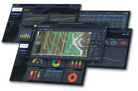
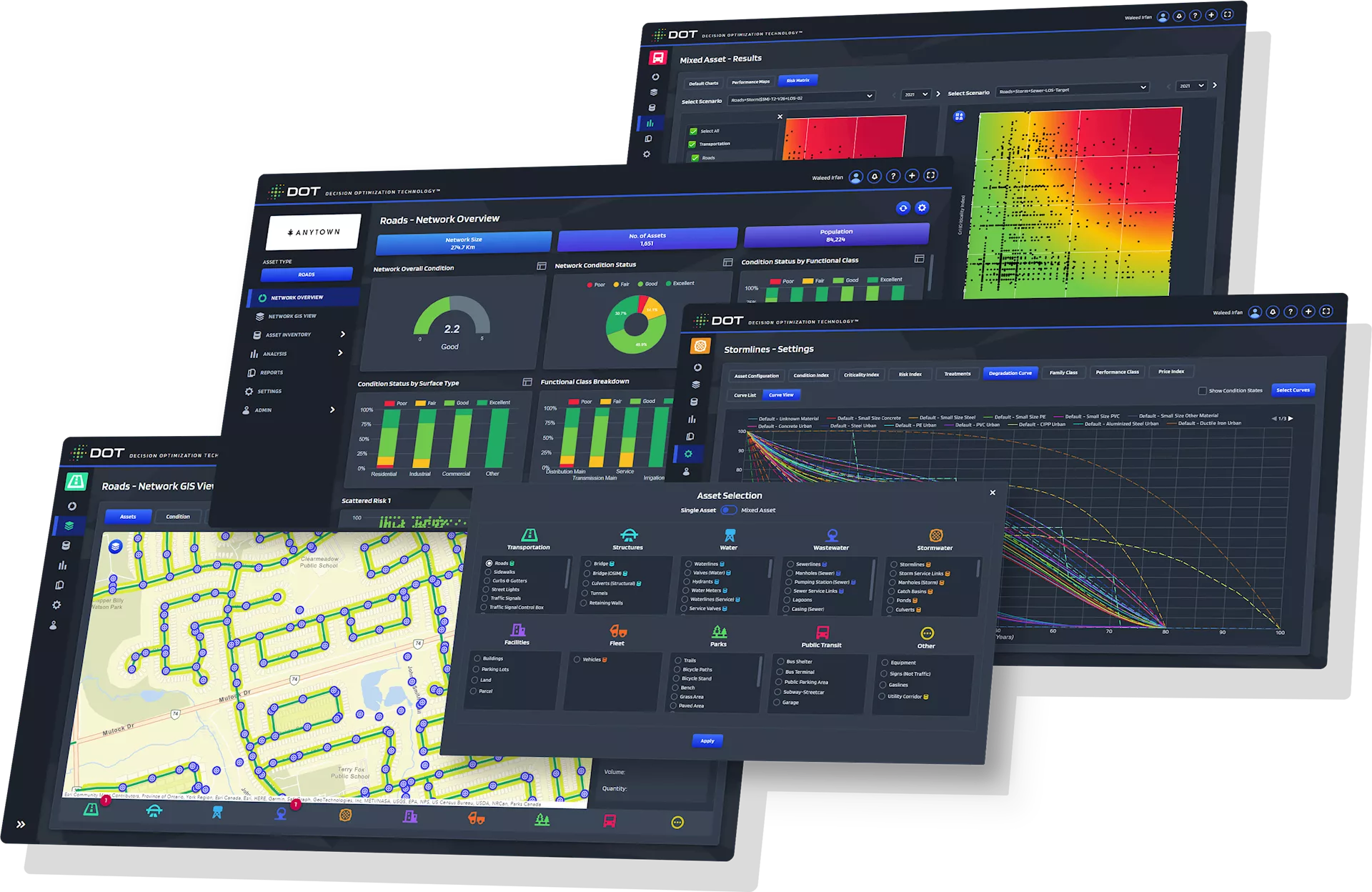
Effective asset management is the cornerstone of building sustainable, smart communities. By integrating AI with GIS, organizations can track utility assets in real time and assess their conditions with greater accuracy, dramatically reducing service downtime. While identifying asset locations and conditions is essential, the true value lies in connecting live data streams to an intelligent system. With AI-driven analytics layered into GIS platforms, stakeholders gain a comprehensive, systemwide view of asset performance, risks and maintenance needs — enabling faster, more strategic decision-making.
Power is a critical backbone to modern life, and appropriately maintaining it is crucial. Using multiple geospatial technologies can yield impactful, resilient, efficient power delivery systems. AI models trained to explore and evaluate geospatial data collected for transmission towers and associated power lines can detect issue-causing factors, such as damage or overgrown vegetation. The integration allows for predicting potential failures, resulting in increased uptime and fewer service disruptions.
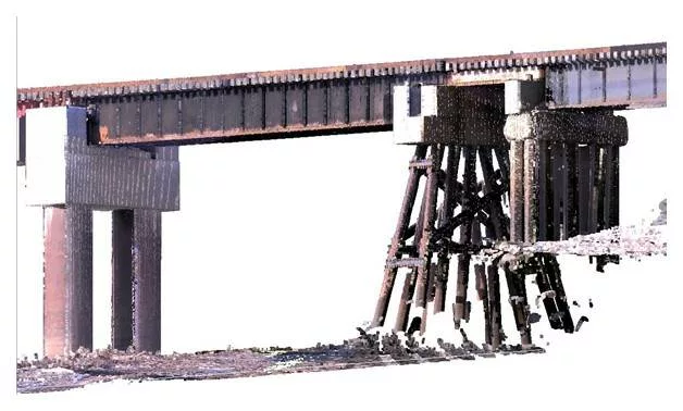
The rail industry supports communities over more than 100,000 miles of track, making system reliability and uptime critical. AI-enabled sensors, coupled with GIS, empower predictive maintenance strategies that help keep this vast network running smoothly. By using AI for spatial analysis, we gain deeper insights into the conditions of these valuable assets, enabling smarter, faster decisions and reducing disruptions.
As AI technologies evolve, GIS will become more dynamic, predictive and responsive. The synergy between spatial science and intelligent systems is not just enhancing maps — it’s transforming how we understand and shape the world around us.