Historically, surveying and railroads have been closely related. Many of the techniques and methods developed during the rapid development of U.S. railroads in the past are commonplace in survey practice and calculations today.
However, over the past decade, the art of collecting data in the field has changed dramatically with the development of newer technology — specifically, 3D scanning and reality capture. This uses a 3D lidar scanner and integrated cameras to collect large amounts of point cloud data safely, quickly and accurately. It can be deployed to a stationary position — such as to collect data from better vantage points for a bridge replacement — on a hi-rail vehicle to collect information on a larger corridor or via an unmanned aerial vehicle, or drone, to capture information from above. Typically, one or more of these methods are used and combined with conventional survey control and field data to process and model the conditions.
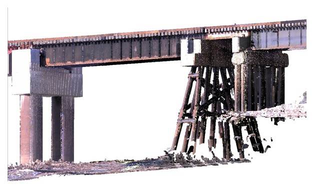 A point cloud image of a complicated railroad bridge
The benefit to the railroad client and design team is that the survey data is captured safer and faster than previous survey methods. Using this technology, the data is typically captured from a point outside the operational corridor, which minimizes or eliminates the time the surveyor has to be on the track. The data is processed, analyzed and extracted to produce the computer-aided design features and surface models the design engineers need, along with additional imagery and point cloud data to visibly assist with the existing site conditions and assessment of their proposed design for the entire team and client.
The added value we have discovered during past projects includes fewer return trips when more site details are requested or additional data is needed, delineating and locating masonry joint lines, detecting structural imperfections, locating high water lines and scour holes, indicating overhead utility connections with vertical clearance details and providing more data for corridor analysis tools. We have also minimized construction schedules and material delays by confirming and comparing the proposed design with the existing conditions using clash detection tools and staging analysis for structural reconstruction projects.
Reality capture technology brings the project site into the office for the entire team to capitalize on, producing a high-quality design and deliverable for the railroad client. Learn more about its benefits by contacting Matt Schrader at mschrader@hanson-inc.com.